Tuggerah Lakes Flood Study Review
Council periodically updates Flood Studies and Floodplain Risk Management Plans for all creeks, lakes, lagoons, and estuaries on the Central Coast. With respect to Tuggerah Lakes, Council adopted the Floodplain Risk Management Plan in 2015, which itself was based on computer modelling data from the Flood Study from 1994. Council has initiated a review of these documents, starting with the Flood Study.
Council has engaged Manly Hydraulics Laboratory (MHL) to prepare a review of the Tuggerah Lakes Flood Study. The study is being undertaken by Council with funding assistance from the NSW Department of Planning and Environment and will be managed in accordance with the NSW Government’s Flood Prone Land Policy.
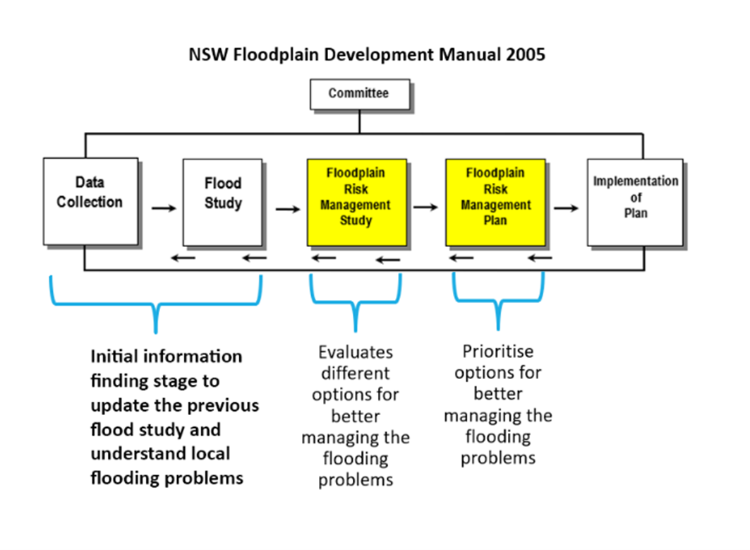
This Flood Study represents an important step in the floodplain risk management process, whereby Council will gain a comprehensive technical understanding of the nature of flooding around Tuggerah Lakes using advanced computer modelling software. Following this study, Council will review the Floodplain Risk Management Plan, which uses the results of the Flood Study as the foundations for developing and reviewing floodplain management initiatives that are designed to help mitigate the effects of flooding.
The aim of the study is to:
- Update the previous flood study using the most current information and technologies
- Help better understand local flooding problems along the lake foreshore
- Build community resilience by informing better planning of development, emergency management and community awareness
- Develop information to assist in future floodplain management activities to reduce flood impacts on the community and risk to life.
Have your say
Community involvement is essential to the success of the floodplain risk management process. It enables the community to:
- Contribute local knowledge of flood behaviour
- Directly influence the calibration of flood models
The community were invited to complete a questionnaire by Friday 16 December 2022. All survey information will be kept confidential and will only be used for floodplain risk management purposes.

Links
Segmented Documents
Timeline
Who's listening
What are the flood risks?
Flooding in the catchment come from three main sources:
- high ocean levels
- high water levels in the lakes and other waterways
- excess stormwater flowing overland
This study will focus on lake foreshore flooding caused by heavy rainfall, elevated ocean conditions (tide and storm surge), long durations of rainfall and/or local wind waves. This study will consider the influence of ocean levels and climate change on such flooding.
What does the study involve?
The study will define flood behaviour across the catchments including flood levels, depths, velocities and their distribution. Flood maps showing predicted extents of flood inundation from the lakes system will be produced. Study results and mapping will be based on flood simulations by detailed computer models developed specifically for the study area. Historical information such as rainfall and peak flood levels can be used to calibrate/adjust the computer flood models, ensuring that they are representative of real local flood behaviour. The results of the study will form the basis of future floodplain and entrance management activities.
What is the Floodplain Risk Management Process?
If you're thinking, "not another study?!", then you will be pleased to know that Council recently completed the Tuggerah Lakes Interim Entrance Management Procedure which guides management of the entrance channel in the lead up to a flood event. Head on over to the website to take a look at the study and procedure.
How can I have my say?
We encouraged the community to contribute to the development of the Tuggerah Lakes Flood Study by completing a Community Questionnaire by Friday 16 December 2022.
Further community consultation will occur during the final stages of this project when the study is being publicly exhibited.
To stay informed and contribute to future developments of this study, please provide your details on the questionnaire provided.
You can find out more about Floodplain Management here, or email FloodManagement@centralcoast.nsw.gov.au if you have any questions.