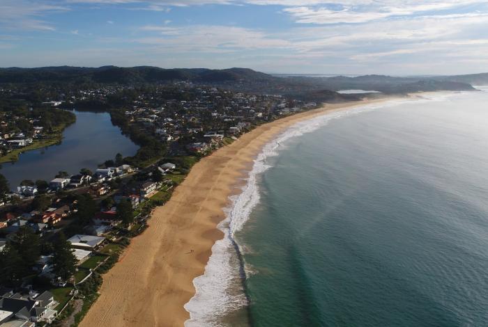
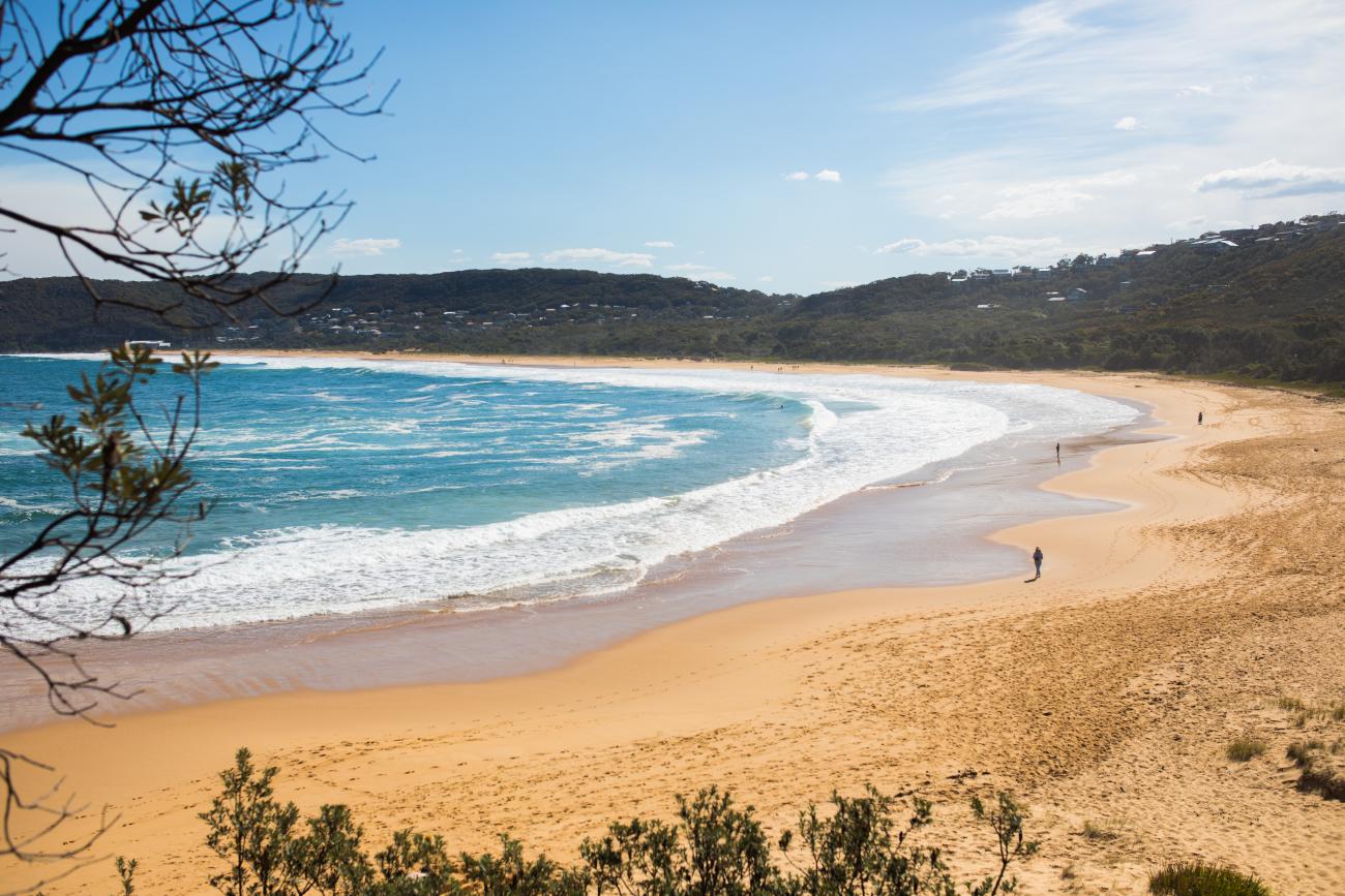
We may be just a tad bias, but we reckon that we live on the best coastline in Australia (and maybe even the world!). From the calm waters of Patonga Beach, the pumping swell at Avoca Beach, the magnificent cliffs at Foresters Beach, the serenity of Cabbage Tree Harbour and the sprawling sand of Budgewoi Beach – the Coast has a huge diversity in its beaches and what they have to offer.
This diversity also makes it a challenging and dynamic Coastline for Council to manage. We currently have 5 Coastal Zone Management Plans which set out the management options for our coastline. A change in the legislation means that Central Coast Council now need to develop one new holistic Coastal Management Program for our open coast, which is a great opportunity for us to review the way we manage our coastal environment.
Community Engagement so far:
Over the years we’ve heard you via:
- your participation in the development of existing Coastal Zone Management Plans
- the feedback you submit on a weekly basis via our Customer Service Centres, emails etc.
- your participation in the Wamberal Beach Terminal Protection and Sand Nourishment - Investigation and Concept Design.
- the waterways survey - view the Our Coast, Our Waterways survey results here
- recent consultation to understand issues and management opportunities along our open coastline.
All this information will be used to assist in informing the Open Coast and Coastal Lagoons Coastal Management Program.
Progress - Previous management plans:
With the diversity of our coastline, comes complexity and over the years there has been a lot of plans, studies and recommendations provided for the management of our incredible coastline. So far 65% of the previously adopted actions have been completed (or are ongoing actions). For the other 35%, it is anticipated that these actions will be carried over into the new Coastal Management Program were appropriate.
Progress – Stage 1 Scoping Study:
Stage 1 Scoping Study for the Open Coast CMP has been completed and reviewed by Council and NSW DPIE staff. It Identified knowledge gaps, recommended Stage 2 studies and provided a forward program for next Stages.
Progress – Stage 2 Technical Studies:
We were awarded a Coast and Estuary grant worth $327,000 from the NSW State Government to allow us to complete the studies needed as the second stage of the CMP development process.
The first study we completed was a Social and Recreational Use Study to understand the recreational use and recreational infrastructure along our coastline and provide a comprehensive series of recommendations for consideration in the development of the new Coastal Management Program.
The second study we completed was a Coastal Hazard Study which was a very comprehensive study of the regional and local coastal processes operating on the Central Coast coastline. The study adopts a data-driven approach and at its centre is an analysis of the Central Coast’s coastal sand budget and a defining of the coastal hazards affecting the Central Coast coastline.
The purpose of the report is to provide:
- an improved understanding of coastal sand movements for the entire Central Coast LGA
- a detailed review and update of Central Coast Council's existing coastal hazard assessment studies using contemporary data and a uniform approach
- the scientific basis for understanding the nature and extent of risks to public safety, built assets, coastal land, cultural heritage/features, ecosystem health and recreational amenity from coastal hazards
- the scientific basis for understanding of the factors that contribute to vulnerability from current and future risks.
Stage 3 Options Assessment:
Stage 3 is all about using existing information and recommendations from stage 2 studies to develop an options assessment, shaped by community consultation. The aim is to identify and evaluate possible management options in order to develop the best management program, guided by scientific evidence and community values.
Consultation update
In January and February this year, we sought community feedback on our open coast using an interactive map and hosted six pop up events at Terrigal, Avoca, Toowoon Bay, The Entrance, Soldiers Beach and Killcare.
We will publish a snapshot of your feedback soon.
The next opportunity to have you say will be during the public exhibition of the draft Coastal Management Plans. Due to the unique management requirements of our coastal lagoons, we will now be developing separate plans for the open coast, and for our coastal lagoons.
We will continue to keep you updated on how you can get involved.
Links
Doc View
Consultation results
Stage 1 Scoping Study
Stage 2 Technical Studies
Timeline View
Who's listening
Consistent with the Coastal Management Act 2016, the objectives of the Central Coast Open Coast CMP is to manage the coastal environment in a manner that is consistent with the principles of ecologically sustainable development for the social, cultural and economic well-being of the people of the Central Coast.
As such, the objectives of the new CMP are:
- to protect and enhance natural processes and environmental values of the Central Coast open coast.
- to support the social and cultural values of the Central Coast and maintain public access, amenity, use and safety.
- to acknowledge Aboriginal peoples’ spiritual, social, customary and economic use of the Central Coast.
- to recognise the subject area as a vital economic zone and to support sustainable coastal economies.
- to facilitate ecologically sustainable development in the Central Coast and promote sustainable land use planning decision-making.
- to mitigate current and future risks from coastal hazards, taking into account the effects of climate change.
- to recognise that the local and regional scale effects of coastal processes, and the inherently ambulatory and dynamic nature of the shoreline, may result in the loss of coastal land to the sea (including estuaries and other arms of the sea), and to manage coastal use and development accordingly.
- to promote integrated and co-ordinated coastal planning, management and reporting.
- to encourage and promote plans and strategies to improve the resilience of coastal assets to the impacts of an uncertain climate future including impacts of extreme storm events.
- to ensure co-ordination of the policies and activities of government and public authorities relating to the coastal zone and to facilitate the proper integration of their management activities.
- to support public participation in coastal management and planning for the Central Coast and greater public awareness, education and understanding of coastal processes and management actions.
- to facilitate the identification of land in the coastal zone for acquisition by public or local authorities in order to promote the protection, enhancement, maintenance and restoration of the environment of the coastal zone.
- to support the objects of the Marine Estate Management Act 2014.
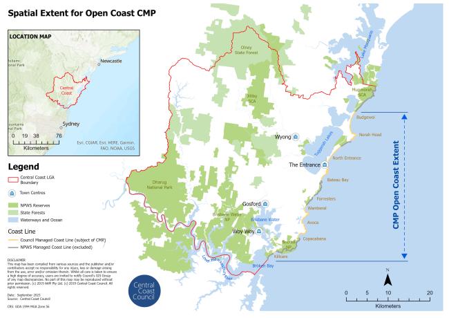
The Open Coast CMP geographical scope includes approximately 80 kilometres of open coast along the Central Coast’s coastline from the southern end of Box Head (Killcare beach) in Bouddi National Park to Snapper Point at the northern end of Budgewoi Beach embayment - including all sandy beaches, several barrier beaches, numerous pocket beaches, intertidal rock platforms, high sandstone cliffs and sections of rocky coasts.
The CMP does not include the Entrance Channel area and Tuggerah Lakes, which will be covered by the Tuggerah Lakes CMP being prepared by Council.

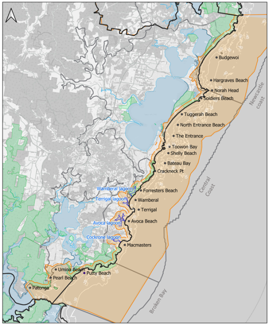
All the sandy beaches from Box Head in the south to Snapper Point in the north are included in this CMP, which are: Patonga Beach, Pearl Beach, Umina Beach, Ocean Beach, Putty - Killcare Beach, Copacabana - MacMasters Beach, North Avoca & Avoca Beach. Terrigal Beach, Wamberal Beach, Foresters Beach, Bateau Bay, Shelly Beach, Toowoon Bay, Blue Bay, The Entrance Beach, The Entrance North Beach, Pelican Beach, Soldiers Beach, Pebbly Beach, Jenny Dixon Beach, Hargraves Beach, Lakes Beach, and Budgewoi Beach.
The four open coast lagoons within the Central Coast LGA (being Wamberal, Terrigal, Avoca, and Cockrone lagoons)will be prepared under a separate CMP which is currently being developed by Council.
Council has a strong tradition of planning for natural hazards, with both former Gosford City Council and Wyong Shire Council having developed a range of strategic and management plans for the coastline and coastal lagoons, including:
- Gosford Lagoons Coastal Zone Management Plan (2015)
- Gosford Beaches Coastal Zone Management Plan (2017)
- Wyong Coastal Zone Management Plan (2011)
- Draft Wyong Coastal Zone Management Plan (2018).
The development of these CZMPs generally follows the structure of the previous NSW planning instruments and legislative framework, guided by the requirements of the former Coastal Protection Act 1979. Since the finalisation of these plans, the NSW Coastal Reforms have changed the way Coastal Management Programs are prepared and implemented. However, these CZMPs do not carry equal status as only the Gosford Beaches Coastal Zone Management Plan (2017) has been certified under the Coastal Protection Act 1979. The Wyong Coastal Zone Management Plan (2018) remains in draft form, due in part because DPIE-Crown Lands did not provide formal agreement to the actions contained within that which were identified as the responsibility of DPIE-Crown Lands (Office of the Minister for the Environment, 2018).
The statutory and policy framework for coastal and marine management was the subject of the New South Wales Coastal Reforms over several years, resulting in the passage of the Marine Estate Management Act 2014 and the Coastal Management Act 2016, which has practical effect through the requirements of the State Environmental Planning Policy (Coastal Management) 2018. The savings, transitional and other provisions of the Coastal Management Act 2016 state that a Coastal Zone Management Plan in force under the former Act ceases to have effect at the end of 31 December 2021.
After 31 December 2021, actions contained within the certified Gosford CZMP will no longer be eligible for State Government funding. In order to continue effective management of the coastline under current legislation, and with the support of the State Government, it is important that Council seek to deliver an updated CMP, in accordance with the CM Act, for part or all of the Central Coast LGA within reasonable timeframes.
Seeking to address the challenges of managing the coastal zone in a coordinated manner, and in accordance with the Coastal Management Act 2016 (CM Act), Council completed the first stage (Stage 1) of the new Coastal Management Program (CMP) process, which comprises the preparation of a CMP Scoping Study for the Open Coast and Lagoons of the Central Coast. The project ran in parallel, and complimented, the development of CMPs for Tuggerah Lakes, Lake Macquarie and the Hawkesbury-Nepean River system (including Brisbane Water and Broken Bay). The framework brings together the coastal management approaches of both former councils into a consistent strategic direction, providing for the integrated management of the coastal environment, confirming and consolidating the delivery of priority management actions by Council and public authorities.
In December 2020, an audit was undertaken by Council of the 323 recommended actions and strategies put forth in the adopted CZMPs. The status of completed and ongoing actions over the total action listed in each CZMPs are as follows:
- Gosford Lagoons CZMP 2015: 21/27 (77.8%)
- Gosford Beaches CZMP 2017: 102/239 (42.7%)
- Wyong CZMP 2011: 43/57 (75.4%)
Council gives effect to many of these actions through the Integrated Planning and Reporting (IP&R) framework and the land-use planning system before being integrated into operational planning processes and resourcing strategies. Individual management actions are assessed for implementation in competition with competing community needs across the Local Government Area. Specifically, Council provides clarity about delivery and intended monitoring indicators for the CZMPs through adopted Delivery Programs and annual Operational Plans which includes relevant information about timing, costs and responsibilities.
Through implementation of existing CZMPs, Council staff have recognised a number of factors that are recommended for inclusion within the new CMP. These include:
- It is important to have well defined and articulated actions in the implementation table, as action wording that is not clear can be interpreted in different ways.
- Implementation actions need to clearly tie in with the objectives of the CMP, be realistic and achievable within the life of the program.
There are examples of existing CZMPs having a very high number of management actions, some of which are considered idealistic, unable to be achieved within the timeframe and / or program funding. Implementation of a robust action review and vetting process is considered important.
The Coastal zone is owned and/or managed by a number of different government agencies, private individuals and other organisations. In practice, Central Coast Council is the forefront of planning and management of coastal zone and coastal lagoons. Management efforts by Council over the past decade or more have been supported (and heavily reliant) on the grant funding from Federal and State governments. The CMP provides a framework for establishing clear ongoing governance arrangements for the coastal zone and relevant government agencies must have regard for the content of a certified CMP.
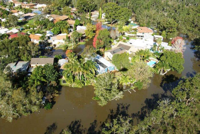
Yes. Coastal Erosion has been identified as a major hazard that had a residual ‘extreme’ and ’high’ risk rating and are recommended for proactive management within the CMP. These include:
- Injury to beach users and/or residents caused by structures mobilising during storm events, or by exposure and mobilisation of buried remnants of historic foreshore protection.
- Injury to beach users caused by erosion, instability of erosion scarps following beach erosion, and undermining at existing beach accessways.
- Loss of house, public assets and other coastal habitats due to storm erosion
- Exposure/mobilisation of potentially harmful sediment, waste, structures, etc.
Significant erosion events have occurred at a number of locations since previous coastal hazard studies were undertaken, a Coastal Hazard Study for the entire open coast and lagoons is completed as part of Stage 2 of the CMP process to define updated risk-based derived coastal hazard lines for use in assessing risks to current and future development. This includes further, updated, definition of other hazards including coastal erosion, coastal inundation and coastal cliff or slope instability, that may be utilised in by Council within a Planning Proposal to define and map a Coastal Vulnerability Area.
Yes. Water quality has been monitored in the Central Coast region since 2002 by Central Coast Council under the Department of Planning, Industry and Environment’s Beachwatch Partnership Program.
This report summarises the performance of 32 swimming sites on the Central Coast of New South Wales, providing a long-term assessment of how suitable a site is for swimming. Monitored sites included ocean beaches, ocean baths, estuarine areas in Brisbane Water, designated swimming areas in Lake Macquarie, Lake Munmorah and Tuggerah Lake, and four coastal lagoons (Beachwatch, 2019).
Major elements of the new CMP focus upon improving water quality through catchment management, review of Council's lagoon entrance management practices, vegetation enhancement and sustainable recreational usage of the lagoon and surroundings. In the forward program for delivery of the Lagoons CMP, a Coastal Lagoons Water Quality & Infrastructure Investigation will be conducted in Stage 2 along with a Coastal Lagoons Water Quality Improvement Plan in Stage 3.
Council has a water quality monitoring program in place for all its waterways, including the coastal lagoons. Routine sampling of the lagoons began in 2017-18. These programs help to understand past and current condition, identify where we need to focus our management actions and determine long-term trends in water quality and ecological health.
Sampling is undertaken by scientists throughout the year at a number of representative sites. Data is collected on site condition, water chemistry, nutrient concentrations and a range of biological indicators which tell us about the health and resilience of each area. The program aligns with the NSW Estuary Monitoring, Evaluation and Reporting Protocols and allows us to compare our results to other estuaries in NSW.
The 2019-20 Waterways Report Card for the Central Coast Local Government Area has been released and includes Southern Lake Macquarie, Tuggerah Lakes, Brisbane Water, the Lower Hawkesbury River and the coastal lagoons – providing a clear picture of our entire waterways network. The 2019-20 report tells us:
- Of the 36 sites sampled, 25% are excellent, 39% are good, 33% are fair and 3% are very poor
- Brisbane Water estuary is generally considered good or excellent, with fair ratings at Narara Creek, Erina Creek and Kincumber Broadwater
- Water quality throughout the Tuggerah Lakes estuary was generally good, with fair results for Budgewoi Lake, Wallarah Creek, Canton Beach, Ourimbah Creek and Killarney Vale and an excellent rating for Chittaway Bay
- The water quality at our southern Lake Macquarie sites is excellent
- Our coastal lagoons vary from excellent at Cockrone Lagoon to very poor at Avoca Lagoon.
Council uses this information to track change, help guide our management decisions and identify areas where more detailed catchment audits are required.
Specific catchment audits were undertaken in the lagoon catchments in response to poor recreational water quality – more information can be found here.
Since 2002, Central Coast Council has worked in partnership with the Office of Environment and Heritage to undertake the Beachwatch water quality monitoring program for the Central Coast. The program provides regular and reliable information to enable local residents and visitors of the Central Coast to make informed decisions about where and when to swim.
Council monitors and reports on the water quality of 32 swimming sites, including 15 ocean beaches, three ocean baths/rock pools, four coastal lagoons, four estuarine netted baths and six lake netted baths. Samples are collected and tested for Enterococci, which are a group of bacteria common to the faecal matter of warm blooded animals. These bacteria indicate stormwater and/or sewage contamination. The test results are used to determine if the site is suitable for swimming.
Results of Beachwatch monitoring are updated on the Council and the NSW Office of Environment and Heritage’s Beachwatch websites during the summer swimming season, providing up to date information for residents and visitors on water quality and whether to avoid swimming at certain locations and/or times.