The Wamberal Beach Terminal Protection and Sand Nourishment studies are now complete. The reports include:
- Stage 1 Literature Review - to take stock of what is known and identify any information gaps.
- Stage 2 Coastal Protection Assessment - to determine sand movement, beach behaviour and impacts/opportunities around public access and amenity.
- Stage 3 Concept Design Options - for a terminal protection structure (seawall) and sand nourishment, and potential seawall alignment.
- Stage 4 Sand Nourishment Investigation - to help maintain public beach amenity.
- Stage 5 Coastal Monitoring Webpage – to monitor beach conditions.
- Stage 6 Cost Benefit Analysis - to guide development of possible funding models.
Next steps
A review of the technical studies, results from the community consultation and consideration of Councils role in relation to coastal erosion has highlighted the need for any terminal protection structure to be:
- located as far landward as possible,
- located wholly on private property where possible
- asset to be constructed, owned and maintained by property owners
- seawall to have the narrowest footprint (to reduce erosion/beach encroachment)
- have the least sand nourishment requirements (both upfront and during the maintenance phase)
While the requirement to meet that criteria highlights options 3 and 4 (which are vertical seawalls) as the preferred designs similar designs that meet the same criteria may be acceptable. The criteria to be met is:
- Any terminal protection structure is to be located wholly on private property where possible
- The asset will need to be constructed, owned and maintained by property owners
- The structure needs to have the narrowest footprint, to reduce erosion/beach encroachment)
- The structure will have the least sand nourishment requirements, both upfront and during the maintenance phase
Council engaged coastal engineers to develop Engineering Design Requirements which will identify specific criteria to guide coastal protection development applications at Wamberal Beach. These guidelines are on public exhibition between 29 June and 27 July 2022 for the community to review and provide submissions. Further information on the Wamberal Beach Terminal Protection Structure Engineering Design Requirements is available here.
You can view the project introduction here and read more about the community consultation here.
Doc View
Who's listening
Faqs View
What was involved in Stage 1 Literature Review?
Stage 1 was to take stock of what is known and identify any information gaps. The objective for this study was to review previous studies related to coastal hazards and coastal management and previous design of terminal protection for Wamberal Beach.
The report contains a compiled review and summary of over 30 studies relevant to the context of the Wamberal Terminal Coastal Protection Assessment.
The Stage 1 report is a review of all of the previous studies, how will this review and the learnings from the previous studies be used to inform decision-making around a preferred solution for Wamberal Beach this time?
Stage 1 outlines information relevant to the context of the Wamberal Terminal Coastal Protection Assessment, demonstrating a long history of coastal erosion. Our understanding of coastal processes and engineering have advanced since the development of those studies, which have influenced new design options being presented in the current studies.
Information gaps in the previous CBA were identified and have been used to inform the new CBA undertaken, particularly by including a distributional analysis.
Previous studies demonstrated funding as a downfall to progression of any long-term solution for Wamberal Beach.
What was involved in Stage 2 Coastal Protection Assessment?
Stage 2 determined sand movement, beach behaviour and impacts/opportunities around public access and amenity. Objectives for this study included:
- existing profile data assembly
- geotechnical data review
- preliminary crest alignment
- beach width analysis
- impact assessment to beach users and beach amenity.
What was involved in the Stage 3 Concept Design Options?
Stage 3 entailed concept design options for a terminal protection structure (seawall), sand nourishment requirements and potential seawall alignment. Objectives for this study included:
- crest alignment
- seawall options – rock, vertical, stepped and hybrid
- cost estimates
- minimum engineering standards.
A total of five seawall concept designs have been developed with cross-section drawings and footprint mapping. The designs range from revetment to vertical and promenade style structures. This study also includes a review of the relevant engineering standards.
Concept render designs were developed as part of the stage 3 report to assist in visualising the concept seawall design options, the concept renders were used to assist in the phase two community consultation. Seawall alignment, access points and terminal ends would be determined during the detailed design phase.
Have environmental studies been undertaken in accordance with the current study?
No. The environmental studies would be undertaken as part of a detailed design phase.
Environmental studies/approvals are a legislative requirement for the construction of a terminal protection structure and sand nourishment operations.
What are the beach amenity impacts of the proposed seawall options for Wamberal Beach?
Table 5.4 Summary of amenity impacts of proposed options for Wamberal Beach (extracted from Stage 2 – Coastal Protection Amenity Assessment) lists impacts for each option.

Where would the terminal protection structure (seawall) be located? On public land or private land? Will land be purchased if a terminal seawall is built on private property?
The Stage 3 coastal engineering assessment proposes terminal protection structure (seawall) alignments for various concept options. Proposed footprints of each concept option can be shown in the report (available online). All concept designs have a proportion of their footprint in private land with large footprint designs (rock revetments and promenade) extending further seaward into public land.
It is important to note that these alignments are concept designs. True alignment would be determined during a detailed design phase and would involve seeking consensus between private and public landholders.
Developing a methodology that can support the coordinated delivery of an embayment-wide solution across a mix of private and public land is one of the key challenges that needs to be worked through.
There are no plans in place to purchase private property.
What was involved in the Stage 4 Sand Nourishment Investigation?
Stage 4 outlines sand nourishment requirements for Wamberal Beach and investigation of potential sand sources including indicative unit cost estimates. Objectives for the study include:
- sand requirements
- sand sources
- sand nourishment cost estimates.
The key objective of Stage 4 is to provide an acceptable level of public beach amenity for the Wamberal/Terrigal embayment over the life of a terminal protection structure.
Does the existing Environment and Planning legislation allow for sand nourishment from alternate sources?
It is possible to use sand from alternate sources but a particular type of sand is required. Where sand is sourced alternatively (i.e. not from the same beach embayment) it must be first deemed a viable source by demonstrating similar characteristics such as grain size/colour and be free of contaminants. The Guidelines for Sand Nourishment Science and Synthesis for NSW is the guiding document for sand nourishment in NSW.
Any operations involving sand nourishment would require environmental assessment and possible environmental protection licences dependent on how sand is applied (i.e. offshore vs on land). The Environment Protection Authority (EPA) issues environment protection licences under the Protection of the Environment Operations Act 1997 (POEO Act).
Sand nourishment operations at Wamberal Beach must be consistent with the Coastal Management Act 2016 and State Environmental Planning Policy (Coastal Management) 2018.
What was involved in the Stage 5 Coastal Monitoring Studies?
Stage 5 consists of additional coastal monitoring studies to observe past and present-day beach conditions to better understand the natural fluctuation of the beach. Monitoring includes:
- installation of a Coastsnap monitoring site on Terrigal Drive
- installation of Trailcam, Lidar wave runup monitoring station
- live Coastal Monitoring Public Webpage to display monitoring data.
What was involved in the Stage 6 Cost Benefit Analysis?
The Cost Benefit Analysis (CBA) assesses the full range of costs and benefits associated with the five concept design protection alternatives (compared to the base case “do normal” approach) to consider economic trade-offs for options to manage future coastal hazards at Wamberal Beach. Also included is a Distributional Analysis (DA) which demonstrates how costs and benefits are distributed. Principles of the report:
- assess the costs and benefits of options for managing the identified threat posed by coastal erosion to Wamberal
- understand the social and economic impacts of each option in terms of housing, local tourism, environmental benefits, beach amenity, supporting industries and the long-term viability of Wamberal.
The CBA and DA will guide the development of possible funding models. The funding model proposal will be a requirement of the DA application.
What information was used to inform the updated Cost Benefit Analysis (CBA)? How will this information differ to the previous CBAs developed?
Information gaps in the previous CBA were identified and have been used to inform the new CBA. This included present day costs and a Distributional Analysis (DA) which demonstrates how costs and benefits are distributed.
Council also provided Balmoral economists with beach use data from the Surf Live Saving Club to assist in determining beach value.
The costs of associated emergency/ongoing maintenance works have been included to assist in predicting the costs of the “do normal” (or do nothing) approach, which was not considered in the previous CBA.
What methodology was used in development of Cost Benefit Analysis (CBA)?
The economic analysis was undertaken by economists from the Balmoral Group Australia (BGA). The CBA was developed in accordance with the Department of Planning, Industry and Environment Guidelines for using cost-benefit analysis to assess coastal management options (DPIE, Sep 2020), coastal engineering inputs and advice from the MHL and WRL project team, and findings from the subsequent stages of the MHL project.
Economic analyses for coastal management is an evolving area of research due to the many variables that make up the coastal zone. The CBA has attempted to resolve many of the assumptions and uncertainties particularly around interpreting the coastal hazard lines.
Terminology used in the CBA:
Net Present Value (NPV) - a method used to determine the current value of all future cash flows generated by a project, including the initial capital investment.
Benefit Cost Ratio (BCR) – a ratio used in a cost-benefit analysis to summarise the overall relationship between the relative costs and benefits of a proposed project. If a project has a BCR greater than 1.0, the project is expected to deliver a positive net present value.
Discount Rate – is the rate that converts future values into present values. The discount rates are 3%, 7%and 10%. By applying a discount rate to future cash flows, the required rate of return is taken into account in the net present value calculation.
Which terminal protection option achieves the highest net present value?
All five options achieve positive NPVs between +$33.1M to +$53.7M over 30-years using a 7% discount rate. Of these alternatives, Option 3 (vertical seawall) is indicated to achieve the highest NPV (+$53.7M).
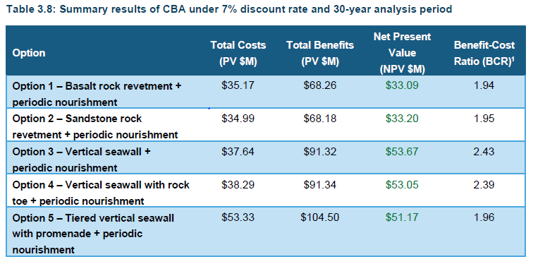
Option 5 (tired seawall with promenade) was also a strong performer achieving a much higher NPV due to improved accessibility and increased visitation.
Central estimates used as inputs into the CBA and are only marginal, and well within the bounds of natural error and uncertainty. Therefore, the results of sensitivity tests, and qualitative factors are expected to play an instrumental role in identifying a preferred option. Careful consideration of aesthetic and other factors difficult to monetarise (such as the significant height of vertical seawalls following major storms) will be required in identifying a preferred option and mitigating any undesirable effects as part of detailed design.
What is the result of the distributional analysis?
All seawall options achieve a positive net present value which means benefits outweigh costs. For all options the majority of benefit falls to the Beachfront Homeowners with the protection provided to private property at-risk to coastal hazards.
Some additional benefit for Options 3-5 (Option 3&4 vertical wall, Option 5 promenade) flows to Non-Beachfront Homeowners with improved beach width relative to the encroachment of present ad-hoc rock works. Option 5 delivers a larger share of benefits to the General Community in the LGA, in addition to the benefits flowing to Beachfront and Non-beachfront Homeowners.
Does the Cost Benefit Analysis (CBA) determine the preferred solution to address erosion at Wamberal Beach?
No. The CBA is only one tool in the decision making. While the CBA provides important information on project costs and who benefits from a seawall, there are many other factors that must be taken into consideration. Such as:
- Viability of each option (sand nourishment requirements, material sourcing, ongoing costs)
- Environmental concerns and constraints
- Community sentiment/feedback
- Asset ownership
- Ongoing maintenance costs
All factors must be taken into account to determine the best outcome for Wamberal Beach.
The Cost Benefit Analysis mentions planned retreat, is that a viable option?
Planned retreat was not included in the scope of the CBA as there is no present policy or mechanism for property reacquisition under planned retreat. Planned retreat was not a recommended action of the certified Coastal Zone Management Plan for Wamberal Beach, in part because it achieved negative present values in previous studies.
Due to ongoing advocacy for some models of planned retreat by some community members, planned retreat is considered in the sensitivity analysis of the report however, these prove economically unviable.
It is important to note that the cost of planned retreat would also need to include demolishing, disposal at landfill and dune remediation which makes this option even less viable.
What is Councils plan for the “68 dwellings identified as potentially impacted by coastal hazards by 2050”? will development applications be assessed?
Any Development Application (DA) submitted will be considered on its merits under the relevant planning controls and certified CZMP.
Can beachfront property owners conduct coastal protection works on their land?
Coastal protection works are subject to an approved development application (DA). Property owners can submit a DA at any time. Council being the determining authority will assess the DA based on its merits.
All DA’s involving coastal protection works must be developed in accordance with local planning and environmental legislation including the Coastal Management Act and Coastal Management State Environmental Planning Policy. Designs must be developed by a coastal engineer.
How long would any proposed (seawall and nourishment) solution last?
The life of any structure would be determined through a detailed design process, the current MHL studies are concept designs. Seawalls on open coast environments, like Wamberal Beach, typically have an initial design life of 50 years. However, many seawalls on the Australian open coast are over 100 years old.
Sand nourishment is central to the long-term solution being investigated. Wamberal Beach is relatively stable. Therefore, any sand added to the beach system through nourishment will remain within the natural system for some time (although it may move back and forth between the dunes, beach and surfzone).
The life span of the proposed program of works will be designed to consider future climate change (i.e. sea level rise). The program of works would be delivered to appropriate coastal engineering standards.
Is Council progressing any of the options to detailed design?
No, detailed design will be requirement of any Development Application lodged.
Council are responsible for assessing the privately submitted development applications against the Minimum Engineering Guidelines, Coastal Management Act 2016 and Coastal Management SEPP 2018.
Is Council developing a funding model for the construction of a Terminal Protection Structure (seawall)?
No, the development of a funding model will be a requirement of any Development Application lodged and it will be assessed as part of the development application process.
What are the next steps for the Wamberal project?
Review of the Manly Hydraulics Laboratory’s (MHL’s) technical studies, results from the community consultation and consideration of Councils role in relation to coastal erosion have highlighted specific criteria for a preferred seawall design which include that:
- The asset to be located as far landward as possible, to reduce interaction with coastal processes and maximise beach width
- It will be located wholly on private property where possible
- The asset to be constructed, owned and maintained by property owners
- The Seawall to have the narrowest footprint, to reduce erosion/beach encroachment)
- It will have the least sand nourishment requirements, both upfront and during the maintenance phase
While these criteria highlight options 3 and 4, which are vertical seawalls, as the preferred designs similar designs that meet the same criteria may be acceptable.
Council is now in the process of engaging coastal engineers to develop Minimum Engineering Guidelines which will identify specific criteria to guide coastal protection development applications at Wamberal Beach. These guidelines will be used by Council in conjunction with the Coastal Management Act 2016 and Coastal Management SEPP 2018 when assessing development applications.