Floodplain Management
Central Coast Council is responsible for the management of flood prone land on the Central Coast. This duty is recognised in the NSW Government’s Flood Prone Land Policy, which aims to reduce the impact of flooding and flood liability on owners and occupiers of flood-prone property and reduce public and private losses.
Council manages flood risk on a day-to-day basis by:
- enforcing planning and development controls aimed at making buildings as safe as possible
- maintaining structures such as detention basins, levees and stormwater drainage assets that are designed to reduce the impacts of flooding
- monitoring conditions that may lead to mechanical intervention at natural outlets to the ocean (such as Tuggerah Lakes and our coastal lagoons)
Beyond the day-to-day activities, it is important for Council to inform the community about potential risks to life and property as a consequence of flooding.
In order to plan for and communicate flood risk effectively, Council follows the NSW Government’s Flood Risk Management Process, which involves periodically completing Flood Studies and Floodplain Risk Management Plans for individual catchments. To learn more about why we complete these studies and plans, please refer to our Frequently Asked Questions below.
Got a question?
General flooding
Flooding on the Central Coast can be categorised into 3 main groups:
- Mainstream flooding – occurs when rivers and creeks start to break their banks and cause inundation of land that is typically dry. In addition to rivers and creeks, when our lakes and lagoons rise and inundate typically dry land, we also consider this to be mainstream flooding.
- Local overland flooding – occurs when intense rainfall overwhelms drainage systems or the ground’s natural ability to absorb water, causing water to flow over the ground's surface and eventually making its way into our rivers, creeks, and other major bodies of water.
- Coastal flooding – normally occurs when dry and low-lying land is submerged by seawater, often caused by tidal or storm-driven coastal events, including storm surge and wind-induced waves in coastal waterways.
Flooding is a natural part of how waterways work. There will always be a possibility of flooding for various reasons and when large volumes or intense rainfall occurs. In some instances, infrastructure can be designed to reduce the impacts of flooding by redirecting flood waters, slowing the water down, or by using flood compatible materials as per Council’s planning instruments.
Everyone has a role to play in managing the risks of flooding – individuals, businesses, emergency support agencies as well as local, state and federal government.
Individual residents and businesses have a responsibility to know their flood risk, to plan for flooding, and to act in a way that protects themselves and their property.
NSW State Emergency Service (SES) is the flood combat agency coordinating emergency response when floods happen.
Council manages flood risk by implementing the Flood Risk Management Process as outlined in the NSW Governments Flood Risk Management Manual (2023).
The NSW Government supports flood risk management by creating policy, providing financial assistance, providing specialist technical advice, and through the provision of emergency management including recovery collection and reviews.
Everyone’s situation is slightly different so a big part of being prepared is taking time to think about what is the safest thing for you to do if a flood happens.
In an emergency, the situation can change rapidly. So, before a flood arrives, it's important to plan and prepare.
Visit Council’s website to find out more on how to plan and prepare for an emergency.
There are several ways to obtain flood information on your property.
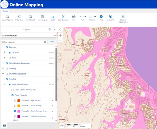
- Council’s Online mapping tool contains visual flood information on a map to help you understand your risk of flooding
- Call Council’s customer service and request to speak to a member of the Floodplain Management team
- Refer to existing Flood Studies and Floodplain Risk Management Study and Plans on Council’s website
If you are looking for flood information specifically in relation to a proposed development, please refer to Developing within Flood Zones FAQ below.
For more information on flooding, visit Council’s webpage via the following link.
Developing within Flood Zones
Generally speaking, flood related development controls apply when a property lies fully or partially within the Flood Planning Area.
The Flood Planning Area is derived in a specific manner for each of our catchments. You can find out if a property lies within the Flood Planning Area by visiting Council’s Online Mapping Tool, or by checking the contents of a current Section 10.7 Planning Certificate (more info on Section 10.7 Planning Certificates is provided below).
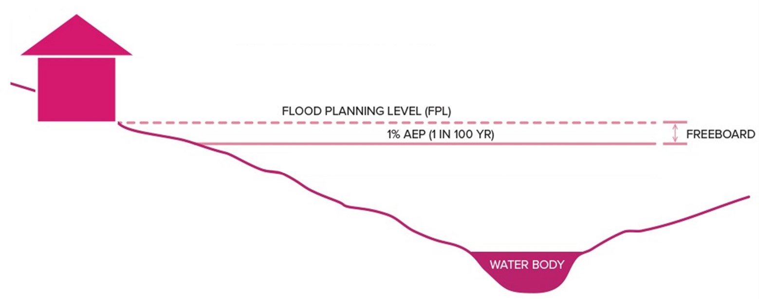
The Flood Planning Level for the Central Coast is a combination of 1 in 100 chance flood level and a specified freeboard. A freeboard is a factor of safety typically used in relation to the setting of minimum floor levels. For residential developments on the Central Coast, this freeboard is 0.5 metres with the addition of a climate change allowance.
A Section 10.7 Planning Certificate, formerly known as a Section 149 Certificate, provides information regarding the development potential of a parcel of land. There are 2 types of Section 10.7 Planning Certificates:
- A Section 10.7(2) certificate shows the zoning of the property, its relevant state, regional and local planning controls and other property constraints such as land contamination, level of flooding and bushfire prone land.
- A Section 10.7(2) and 10.7(5) certificate provides the same information as above. It also includes advice from other authorities and certain information a Council holds on a property that is relevant to the land but is not disclosed in a Section 10.7(2) certificate.
Under NSW legislation, a contract for sale of a property must include a current Section 10.7 Planning Certificate from the relevant local Council.
Chapter 9 of the Section 10.7 Planning Certificate specifically relates to flooding and will identify if the property is subject to flood related development controls.
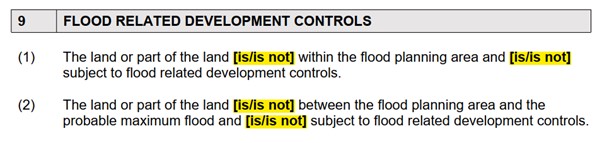
Often a property will not be subject to flood related planning controls in clause (1), but is subject to flood related planning controls in clause (2). This is in part due to the fact that more stringent planning controls may be placed on sensitive development such as aged care centres, child care centres, medical facilities etc., and thus it is important to identify a properties flood affectation right up to the Probable Maximum Flood (the worst flood that can conceivably occur based on computer modelling).
Potentially, yes.
Following the completion of a flood study, Council’s flood mapping will be updated. Naturally, this means the extents of the Flood Planning Area and Probable Maximum Flood will change. The change may be marginal in some areas, it may be more significant in others, but ultimately is does mean the contents of a Section 10.7 Planning Certificate will be updated accordingly.
This is why it is always important to check the currency of a Section 10.7 Planning Certificate by making sure a new study for your area hasn’t been completed since receiving a certificate.
Not necessarily – this simply means that if there is a development proposal on the land, such as a building a new house, then it would need to consider the flood risk so that the future occupants can live safely on the land and minimise risk to life.
For example, you may be asked to build on a certain part of your land, elevate your floor level to a minimum acceptable level, build with flood compatible materials, have a suitable flood evacuation plan, have a refuge location at a level equivalent to the Probable Maximum Flood, or even provide evidence that your proposed development will not have negative flood consequences on neighbouring properties.
Ultimately, any proposed development on flood prone land will be subject to careful assessment which incorporates consideration of local circumstances.
We recommend obtaining a Flood Information Certificate and/or booking a pre-development meeting with our Development Team to help you understand these considerations.
House prices vary continuously with changes in the real estate market and are based on a large range of factors including, but not limited to, location, size and age, which are not under the control of Council. The impact of flood related development controls also varies greatly from one property to another, so a section 10.7 planning certificate notation may or may not affect property values.
Regardless, Council has a responsibility to inform the community, which includes future property owners, as clearly as we can about potential risks to life and property. We also have legal and moral obligations to let current and future owners know about any development controls which may apply to a specific property – this is achieved through contents of the Section 10.7 Planning Certificate.
Consider a scenario where your neighbour wants to build a shed in their backyard. That shed however will divert runoff down your side path, preventing you from being able to exit your property during a heavy downpour. The notation on your planning certificate effectively notifies Council that the lot is flood affected, and therefore any future development must be in accordance with local planning controls. Situations like this make it abundantly clear how important it is for Council to identify properties that are flood affected, as it reduces our communities overall flood risk and risk to life.
Complying Development is a fast-track approval process for straightforward residential, commercial and industrial development. From 1 July 2021, all Complying Development Certificate (CDC) applications must be lodged through the online NSW Planning Portal. If the application meets specific criteria, it can be determined by a registered certifier.
Under Clause 3A.38 of the Codes SEPP 2008, development must not be carried out on any part of a flood control lot that is considered to be in one of the following exclusionary categories:
- a)flood storage area
- b)floodway area
- c)flow path
- d)high hazard area
- e)high risk area
A Flood Information Certificate will provide a table indicating if any of the above categories affect the lot. More details on Flood Information Certificates are provided below.
Council’s Online Mapping Tool allows you to determine if a property is subject to flooding.
However, if you require more detailed flooding information (e.g for a Development Application or Complying Development purposes), you can complete an application for a Flood Information Certificate via Council’s Property and Payments Portal. Simply create an account and follow the prompts.
Flood Information Certificates contain information such as flood depths, flood levels, flood hazard, hydraulic categories, and an automated minimum floor level.
The following two options are available for purchase:
- -Standard Flood Information Certificate – delivered within 15 business days of lodgement
- -Urgent Flood Information Certificate - delivered within 3 business days of lodgement
Click this link to view an example of a Flood Information Certificate.
Our flood maps show which properties are expected to be affected by flooding. Even if a small portion of the property is affected, the whole property will still be classified as flood affected and will be noted on a Section 10.7 Planning Certificate accordingly. This does not mean that your home will necessarily flood.
Development planning controls are applied to a whole property and cannot be split. Application of Council’s flood related planning controls do however depend on where the proposed development is located, and what type it is.
A Local Environmental Plan (LEP) is the primary legal planning document for guiding land use and planning decisions made by Council. An LEP outlines the permissible land uses and is accompanied by maps that detail various aspects such as land use zones, building heights, and lot sizes.
A Development Control Plan (DCP) provides detailed planning and design guidelines to support the planning controls in the Local Environmental Plan (LEP) and is prepared and adopted by Councils.
Click the following link to access Council’s DCP and LEP.
The Flood Risk Management Process
The NSW Government’s Flood Prone Land Policy, as outlined in the NSW Government’s Flood Risk Management Manual aims to reduce the impacts of flooding and flood liability on communities, owners and occupiers of flood prone property, and to reduce private and public losses resulting from floods. According to The Policy, local Council’s are ultimately responsible for managing flood risk in their own Local Government Areas. The Manual and supporting guidelines were gazetted in 2023 to aid local council decision making and to promote good practice in flood risk management.
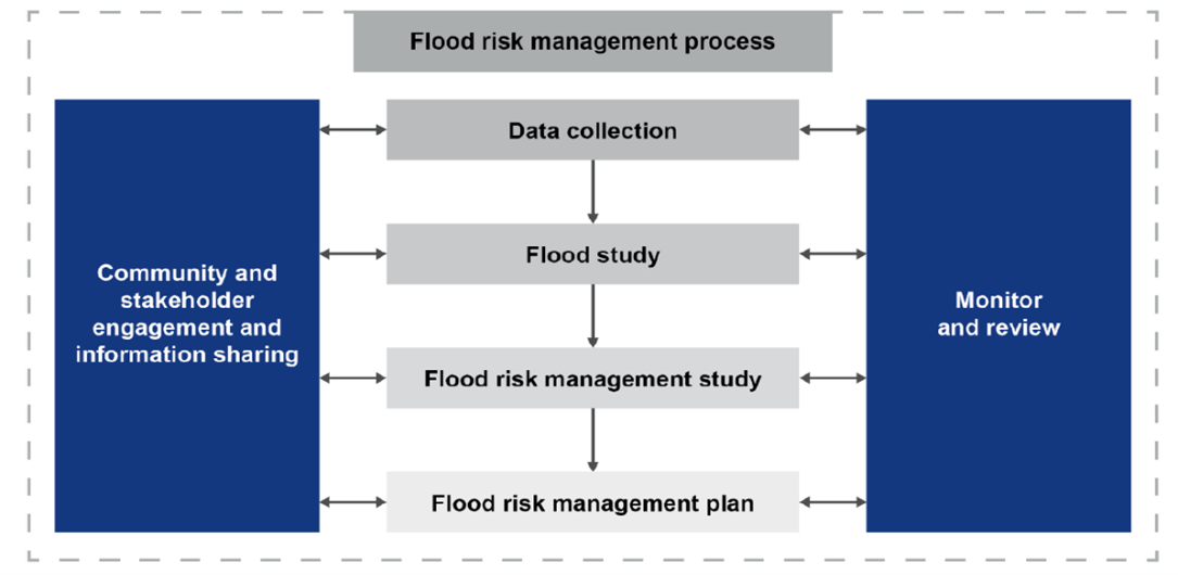
- Data collection – gathering of the necessary information to support the study being undertaken. A means to prepare well-informed studies that can facilitate informed decisions.
- Flood study – aims to define flood behaviour in sufficient detail to support the understanding and management of flood risk. This is primarily achieved through flood modelling.
- Flood risk management study – provides the basis for examining and recommending management measures. Options are assessed against a range of performance criteria related to their effectiveness, efficiency, practicality, feasibility, and community and environmental impacts.
- Flood risk management plan – builds on the recommendations of the flood risk management study by outlining how council will effectively manage flood risk in the study area into the future for the benefit of the community. Study and plans are often completed as a single project.
The NSW Government’s Department of Climate Change, Energy, the Environment, and Water (DCCEEW) manage what’s called the Floodplain Management Program. Under this program, DCCEEW provide both financial and technical support to local government in preparing studies and plans associated with the Flood Risk Management Process. They also assist in the implementation of said plans.
The NSW Government usually offers assistance by providing $2 for every $1 provided by councils for approved projects.
Existing studies and plans naturally become outdated with time, and thus, should be reviewed on a periodic basis. This may be a function of various factors such as:
- Updates in industry guidelines supporting best practice
- Improved flood modelling technologies
- Availability of additional flood monitoring data
- Changes to the floodplain overtime due to development
Council have a responsibility to provide the community with the most up-to-date flood information available, and thus it is important to ensure our data and flood information remains relevant and accurate.
To view Councils existing Flood Studies and Plans, visit council website via the following link.


