Engagement Summary
To read in further detail how we connected, and what we heard during public exhibition in 2026, view the Engagement Summary.
The masterplan is under review following exhibition. Feedback will be used to update the plan before it goes to Council for adoption in late 2026.
The draft Hardys Bay Foreshore Masterplan was on exhibition between 16 March and 13 April 2026.
The feedback has helped Council better understand the community’s priorities for the Hardys Bay foreshore. Key themes raised included:
We also heard strong support for the overall direction of the masterplan, including its focus on improving access, safety and the long-term environmental health of the foreshore.
To read in further detail how we connected, and what we heard during public exhibition in 2026, view the Engagement Summary.
Council is now reviewing all feedback received and considering appropriate amendments to the masterplan. The final masterplan is expected to be reported to Council for adoption in late 2026 (Q2 FY2026-27).
Council, in collaboration with the Wagstaffe to Killcare Community Association (WKCA), has prepared a draft masterplan for the Hardys Bay Foreshore, from Rocky Point to Wagstaffe.
In 2025, the community shared feedback through an online survey, interactive map and information sessions. This feedback has been used to refine the draft masterplan, which was on public exhibition.
The draft masterplan sets out a long‑term vision to improve access, safety and the environmental health of the foreshore, informed by local knowledge and community priorities.
Public exhibition period
Scroll through pages 20 to 53 to see the details of each precinct and node of the masterplan
Provide a clear recognition of the issues to be addressed, as expressed by the community
Provide a design response addressing those issues which would be supported by the community
Provide a clear basis for detailed design and costing of various features or works identified in the plan
Enable the elements of the plan to be progressively implemented, recognising that funding over time will be a key determinant
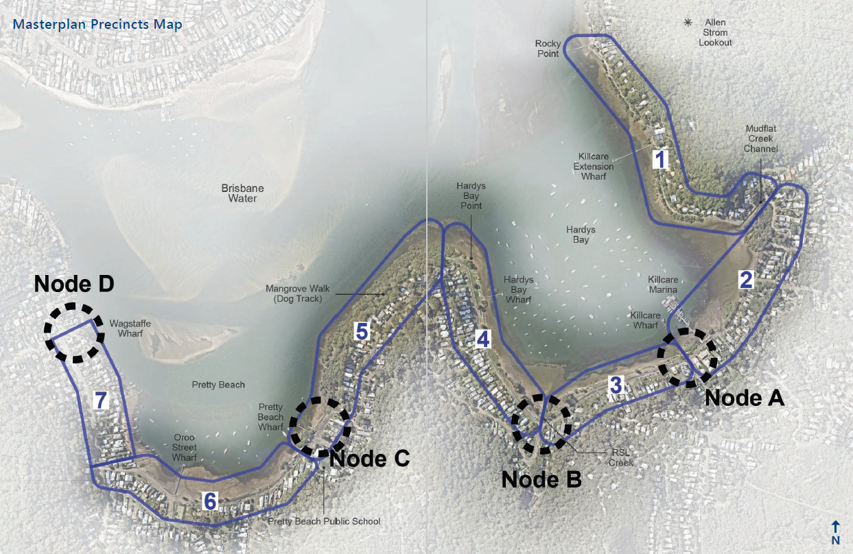
The study area has been divided into the following seven precincts:
In addition, four key nodes have been identified for more detailed study.
These are mapped below.
The following design principles have been applied across all precincts in the study area.
“We are all, always, on Country”.
The Masterplan Working Group has consulted with, and received general support from Darkinjung Local Aboriginal Land Council and Wannangini Ltd. Central Coast Council has commissioned Wannangini Ltd to undertake a Due Diligence Study which includes the Hardys Bay Foreshore Masterplan (HBFM) area to gain a clear understanding of the need for a formal Aboriginal Cultural Heritage Assessment Report (ACHAR) and any Aboriginal Heritage Impact Permits (AHIPs).
The foreshore is approximately 4 km long and typically very narrow, providing a linked “ribbon” of space along the foreshore. Its impact on the visual and physical environment is significant, and its importance and value to the community is high.
Key Masterplan design objectives are to maintain the unique local character of each precinct and link them by providing continuous and safe access, while retaining visual connections to the bay and surrounding landscape.
Outlook over the bay is a primary feature of the locality. A key principle is to maintain or enhance view opportunities from the public domain. This requires careful consideration when proposing new shade trees and other vegetation in public open spaces to ensure views from adjacent roads, pathways and residences are not adversely impacted.
The Masterplan promotes the provision of a continuous shared pathway along as much of the foreshore as possible. This will increase access and enjoyment for the entire community, including families with strollers, walkers, cyclists, school children, people in wheelchairs and others with limited mobility.
It is proposed that the journey along the pathway should be an interesting experience. This may include variations in width or shape, the use of different materials, textures and colours, and the inclusion of artistic elements within the pathway surface that reflect the character or history of each location.
The design approach aims to creatively integrate all landscape elements, including planting, pathways, seating, shelters, signage, bins and bubblers. The design must respect and enhance the natural character of the foreshore and the unique character of each precinct.
Low maintenance and sustainability are key design criteria, with preference given to tree and plant species endemic to the area.
The design approach seeks to address the loss of public open space and exposure of drainage pipes caused by foreshore collapse in certain areas. Areas most subject to tidal and wind‑wave erosion are to be protected using appropriate and sympathetic techniques, allowing for the reclamation of lost public open space.
Access to the water from the foreshore edge at key locations will be enabled using soft access or natural stepped access, where appropriate.
The design of the foreshore public domain includes the adjacent roadway and its impact on accessibility, safety and amenity. This applies throughout the study area, including Hardys Bay Parade, Araluen Drive, Pretty Beach Drive and Wagstaffe Avenue.
Pinch points should be corrected, roadside drainage resolved and road surfaces renewed. Priority will be given to casual parking for residential and visitor use along the foreshore, consistent with safety considerations. Subject to further study, and where required to manage higher traffic volumes in areas of narrow carriageway, parking may be restricted to one side.
To share your feedback on the draft Masterplan for Hardys Bay Foreshore, you could:
When providing feedback to Council your attention is drawn to the provisions of the Government Information (Public Access) Act 2009 which allows for possible access to certain public and personal documentation. View our privacy statement.
If you require further information, please contact Council’s Customer Service Centre. Any written feedback provided may also be made publicly available as (de-identified) verbatim comments in the reporting process.
During 2024, Council sought community feedback to inform a Hardys Bay Foreshore Masterplan. Council is required to develop Coastal Management Programs (CMPs), in accordance with the NSW Management Framework. Coastal Management programs set the long-term strategy for the management of the coastal zone including our lakes, lagoons, estuaries and beaches.
The Hawkesbury-Nepean River System CMP will be valid for 10 years and will reflect the latest advances in technology and ecology, and account for changes in the pressures and desires of our community.
The Hardys Bay Waterfront Masterplan will be incorporated into the Hawkesbury-Nepean River System Coastal Management Program (HNR CMP), which is currently being developed. Council is working with the local Hardys Bay community to inform the development of the Hardys Bay Waterfront Masterplan.
Once developed, the Masterplan will outline the overall vision for the Hardys Bay waterfront precinct and provide a conceptual layout to guide future projects and infrastructure.

Council sought community feedback between 16 September 2024 and 1 December 2024 via
Members of the local community were invited to share their thoughts in person and online.
In addition, Council also hosted two ‘drop-in’ sessions where members of the public could meet Council staff to discuss their concerns.
Drop-in sessions held at Hardys Bay Community Church:


The community were invited to 2 pop-ups to meet with the Project Team and the teams from Waterways and Community Engagement.

General agreement on the need for an accessible and continuous pathway or walkway to enhance safety and connectivity.
Concerns over deteriorating roads and lack of footpaths along Araluen Drive, making pedestrian movement difficult.
Concerns about abandoned and rotting dinghies cluttering the foreshore.
Strong resistance to overdevelopment. Residents want to maintain the area's charm as a village like community.
Increased planting of medium-sized shade trees to provide natural cooling, bird habitat, and erosion control.
Poor drainage and low road levels are recurring concerns, with water pooling after rain impacting usability and accessibility.
![]()
Have questions or want to learn more about a current engagement project? Contact us below:
| Name | Community Engagement Team |
|---|---|
| engagement@centralcoast.nsw.gov.au | |
| In writing | PO Box 20, Wyong, NSW, 2259 |
For general feedback and enquiries about Council, contact Customer Service:
| Name | Customer Service Team |
|---|---|
| Phone | 02 4306 7900 |
| ask@centralcoast.nsw.gov.au | |
| Website | centralcoastcouncil.custhelp.com |
| In writing | PO Box 20, Wyong, NSW, 2259 |


