Flood study closed
Central Coast Council is progressing a series of flood studies across the region, aimed at improving community safety, resilience and preparedness for flood events. Residents are invited to comment on several flood studies that are currently open or will be open for public exhibition.
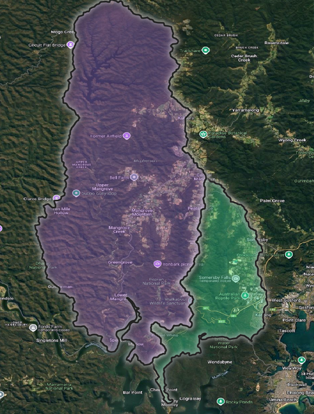
Council has received financial support from the State Floodplain Management Program, administered by the Department of Climate Change, Energy, the Environment and Water, to undertake a comprehensive flood investigation of the Mangrove Creek and Mooney Mooney Creek catchments. Mangrove Creek (including Popran Creek) and Mooney Mooney Creek catchments drain to the lower Hawkesbury River from the western edge of the local government area on the Central Coast Plateau.
Central Coast Council will engage a consultant to undertake this study which covers the area in the map below. In particular, the suburbs and rural development areas of Calga, Central Mangrove, Glenworth Valley, Greengrove, Gunderman, Kulnura, Lower Mangrove, Mangrove Creek, Mangrove Mountain, Mooney Mooney Creek, Mount White, Peats Ridge, Spencer, Ten Mile Hollow, Upper Mangrove, and Wendoree Park.
The Mangrove Creek Dam, Upper Mooney Mooney Creek dam and the old Lower Mooney Mooney Creek dam, are also included in the study area. All three dams are owned and operated by Central Coast Council as the local Water Authority.
Have your say by taking our survey
We value local knowledge and personal community experiences, as it provides valuable insight into past floods.
By completing a short survey, you’ll be helping Council to identify flooding ‘trouble spots’ and prepare a draft flood study. Later this draft study will go on public exhibition, and you will have the opportunity to make a submission or comment to ensure that we have developed an accurate computer flood model.
The survey is available from Monday 27 October to Monday 24 November 2025.
To share your feedback, you can:
- Complete the online survey (below)
- Email: engageme@centralcoast.nsw.gov.au
- Write to Council: PO Box 20, Wyong NSW 2025
Survey closes Monday 24 November 2025
Your attention is drawn to the provisions of the Government Information (Public Access) Act 2009 which allows for possible access to certain public and personal documentation. View our privacy statement.
More information
Check out the FAQs to learn more about what a flood study is, why an update is needed, the flood risk management process we follow, the different types of flooding and more.


