We're reviewing your feedback
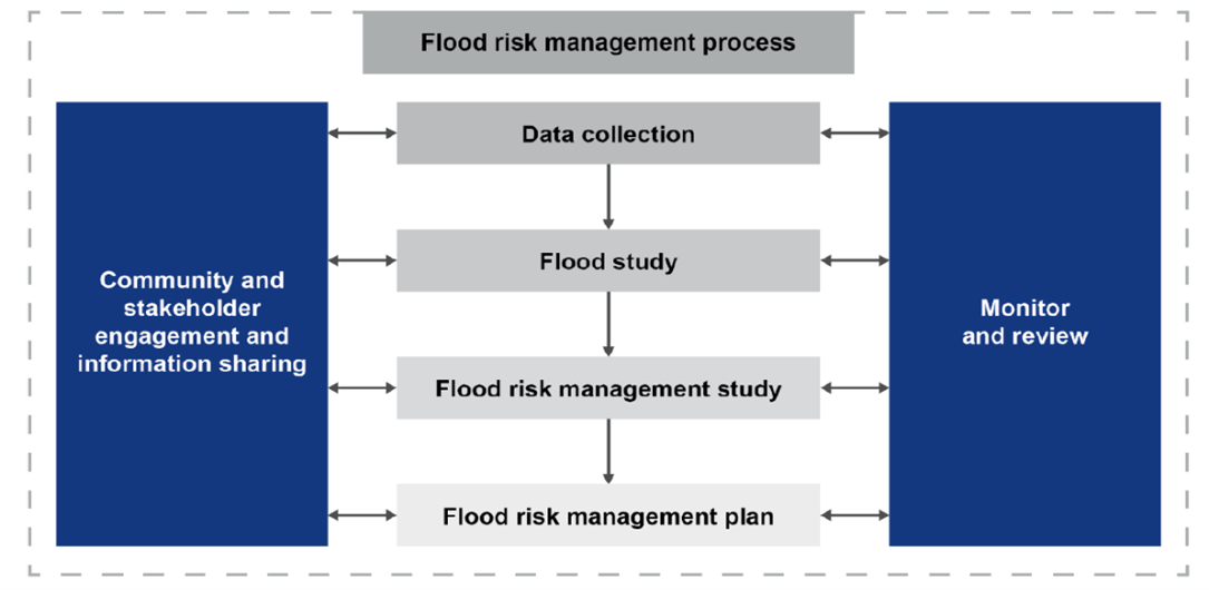
Central Coast Council is committed to keeping our community safe and well-informed about flooding. To do this, Council regularly updates Flood Studies and Floodplain Risk Management Plans for all catchments across the Central Coast.
Council has commissioned flood consultants Golder and Hydrostorm to prepare a Floodplain Risk Management Study and Plan (the Plan) for Narara Creek which flows through the suburbs of Narara and West Gosford. The objective is to evaluate options that can better manage the existing, future and continuing flood risk.
Flooding is Australia’s most expensive natural disaster, having claimed over 1,900 lives and costing insurers around $2 billion annually. Despite this, flood risk can be effectively managed using hydrological and hydraulic modelling to predict flood behaviour.
A Floodplain Risk Management Study and Plan (FRMSP) will help Council understand existing flood patterns, identify priority areas for mitigation, support emergency management, and guide future development.
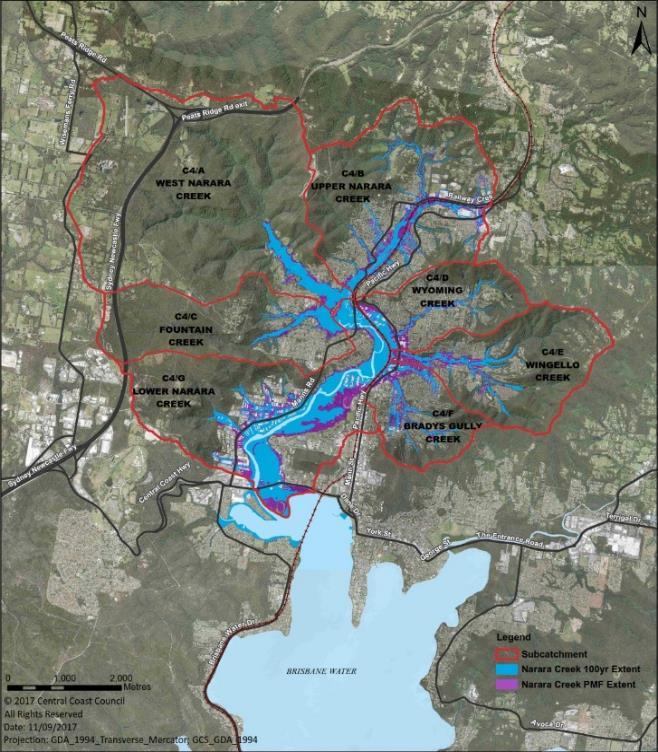
The Narara Creek Floodplain Risk Management Study and Plan (FRMSP) covers the catchment area which flows through the suburbs of Narara and West Gosford. The FRMSP catchment area covers the sub-catchment areas of:
- West Narara Creek
- Upper Narara Creek
- Fountain Creek
- Wyoming Creek
- Wingello Creek
- Bradys Gully
- Lower Narara
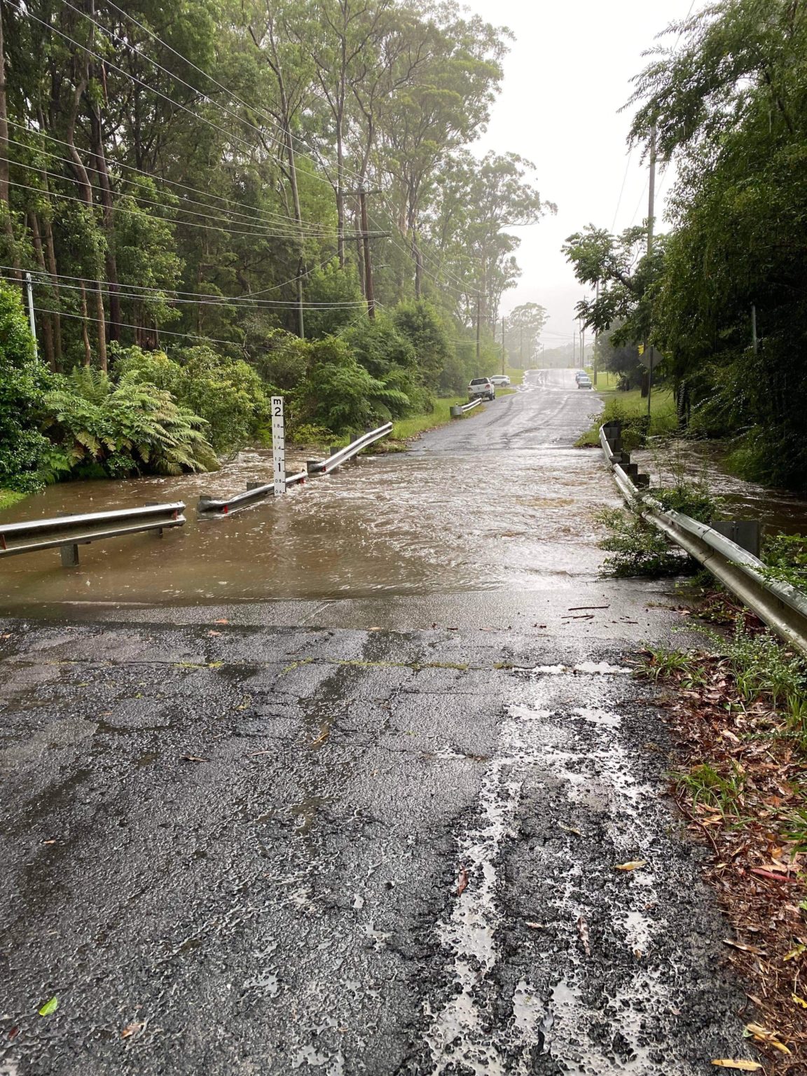
The catchment experiences three types of flooding mechanisms:
- Overland flooding in the upper reaches
- Fluvial flooding from major waterways, and
- Coastal flooding from the Brisbane Water Estuary.
Catchment flooding occurs over a much shorter duration in contrast to coastal storm surges, which typically have a longer duration.
The FRMSP objective is to evaluate options that can better manage the existing, future and continuing flood risk.
Your involvement is essential to the success of the floodplain risk management process as it enables Council to:
- Shape decisions that reflect community needs
- Improve community safety and preparedness
- Inform land use planning and development decisions
- Support emergency response planning
- Build community resilience to future flood events.
Once the Plan is finalised and adopted by Council, the recommended actions identified within the Plan become eligible for grant funding from various external departments including DCCEEW (Department of Climate Change, Energy, the Environment and Water) under the NSW Floodplain Risk Management Program.
The actions will be incorporated into Council’s future plans and implemented as resources and funding allow.
Images
Image 1 of 3
Key actions in the Plan
In the draft Plan, a range of flood mitigation actions have been identified to manage flood risk.
These actions were assessed through a multi-criteria analysis considering factors such as capital cost, benefit-cost ratio, flood impact, emergency response, social and environmental impacts.
Flood Modification Actions
| Priority level | Code | Description |
| Medium | FM3.1-C4/B | Local drainage study recommended for further investigations. |
| Priority level | Code | Description |
| Medium | FM3.3-C4/B | Enhance local trunk drainage to minimise overland flow flooding from the west of Koninderie Pde Detailed trunk drainage analysis is required. Can be undertaken along with Option FM3.1-C4/B. |
| Priority level | Code | Description |
| Medium | FM4.2-C4/B | This option reduces the flood levels from approximately 0.2 m near the bridge to 0.01 m further upstream to the limit of impact of this option. The bridge upgrade will not only provide greater capacity but also lowers the potential for debris blockage. |
| Priority level | Code | Description |
| Medium | FM2.2-C4/G | Prevents overbank flooding from Narara Creek. Investigate the potential to raise the lower end of Dell Road. Could be incorporated into any future upgrade with Transport for NSW. |
| Priority level | Code | Description |
| Medium | FM3-C4/G | Floor levels for more than 60 properties in the industrial area are close to street level and are likely to flood, causing damage. Trunk drainage improvement may be considered in this area. Detailed trunk drainage analysis is recommended. |
| Priority level | Code | Description |
| Medium | FM6.1-C4/G | The creek has limited conveyance due to high vegetation growth in parts of the channel. Eroding banks also contribute sediment transport to Narara Creek and ultimately Brisbane Water. Creek works similar to Rivercare works could improve conveyance and help prevent excessive regrowth of vegetation. An added benefit is reduced sediment generation and transport, supporting Brisbane Waters Management Plan objectives for both flooding and water quality. |
| Priority level | Code | Description |
| Medium | FM8-C4/G | Raising Central Coast Highway above the 1% AEP flood level with provision of cross to reduce the depth of flooding on highway. This option is to be undertaken by Transport for NSW (TfNSW). |
| Priority level | Code | Description |
| Low | FM2.2-C4/B | A levee is proposed at the northern end of the Koninderie Parade to prevent overtopping at that location. Model run undertaken for the 1% AEP event shows beneficial impact to properties. Can potentially be combined with Option FM4.2-C4/B |
| Priority level | Code | Description |
| Low | FM3.2-C4/B | A detailed drainage analysis for the local catchment is required to manage the flood risk, including the provision of effective flood evacuation in a PMF event. |
| Priority level | Code | Description |
| Low | FM4-C4/C | Upgrade road access to the 1% AEP flood level. Would require a bridge or multi-cell culvert. Extensively requested in the recent community survey. Can form part of a flood evacuation route for the West Narara area. |
| Priority level | Code | Description |
| Low | FM1-C4/D | Blocking the flow from Narara Creek via the existing blocking underpass to create a flood retarding basin for the local catchment flows benefits the industrial area. Bike path would need to be relocated if this option is implemented. Properties in Showground Road would need to be protected for likely flood impact |
| Priority level | Code | Description |
| Low | FM2.3-C4/G | The racecourse and golf course provide flood storage during significant flood events. Development controls have been retained in the current DCP specific location schedules to help manage flood risk. |
Property Modification Actions
| Priority level | Code | Description |
| High | PM1.3-C4/G | Development controls as per Council's current DCP should be applied, including safe refuge and a flood warning system. |
| Priority level | Code | Description |
| High | PM1.2-C4/G | Specific control for this area includes evacuation planning during flood emergency and flood warning system. |
| Priority level | Code | Description |
| High | PM1.1-C4/G | Development controls as per Council's current DCP should be applied. A Drainage Master Plan should be prepared to identify the secondary flow paths. |
| Priority level | Code | Description |
| High | PM6-All | Hazardous materials in flood-prone industrial areas must be managed through development controls (e.g. bunding and site-specific investigations) to minimise environmental risks during flood events. |
| Priority level | Code | Description |
| High | PM1.2-C4/B | Tighter development controls would include building habitable floor levels to flood planning level, flood compatible construction, safe evacuation or refuge in place. |
| Priority level | Code | Description |
| High | PM1-All | A comprehensive planning matrix should be developed to account for the varying degree of flood risk in a floodplain. The DCP can be improved by incorporating controls related to climate change and updating the planning documents every few years. |
Emergency Response Modification Actions
| Priority Level | Code | Description |
| High | EM6-All | A Business Safe brochure to be prepared by the SES. Information sessions to be held for various business communities. |
| Priority Level | Code | Description |
| High | EM2-All | Training of SES and other Council Officers in its flood intelligence capabilities should be undertaken. |
| Priority Level | Code | Description |
| High | EM8-All | Recommends preparation of Flood Emergency Response Plan for large establishments such as aged care facilities and hospitals. |
| Priority Level | Code | Description |
| High | EM3-All | Information provided to SES by Council. MHLFIT training in using predictive warning tool should be undertaken. |
| Priority Level | Code | Description |
| High | EM5-All | A comprehensive community education program to be prepared by SES in association with the Council. |
| Priority Level | Code | Description |
| High | EM4-All | Local flood plan to be updated by SES with new flood data, including evacuation routes and Flood Emergency Response Classification of communities. |
Feedback now closed
You were able to provide your feedback by:
- Viewing the draft Narara Creek Floodplain Risk Management Study and Plan
- Completing the online submission form
- Attending a drop-in session
- Emailing: engagement@centralcoast.nsw.gov.au
- Writing to Council: PO Box 20, Wyong NSW 2259
Drop-in Sessions at Niagara Park Stadium
You could meet the Central Coast Council Floodplain Management team and members from the Department of Climate Change, Energy, the Environment and Water to learn more about the study and plan.
Address:
18 Washington Ave
Niagara Park NSW 2250
Tuesday 23 June 2026 04:00 pm to 07:00 pm
Thursday 25 June 2026 04:00 pm to 07:00 pm
Central Coast Council collects information on the Your Voice Our Coast website to understand community views and help inform Council decisions. Providing information is voluntary. If you provide feedback anonymously, Council will not be able to contact you further.
Your feedback will be accessed by authorised Council officers and may be shared within Council, and with Council’s agents and contractors, where lawful and necessary to support Council functions and service delivery. Any written feedback may also be de-identified and published in reports.
Your personal information will be kept in Council's Information Management System in accordance with the relevant legislation. Council's address is 2 Hely Street Wyong NSW 2259. Your information will also be held by Open Point (the Your Voice Our Coast platform provider) and Council recommends you read their privacy statement.
You may access, correct or update your personal information by visiting Council’s website, contacting Council's Privacy Contact Officer on 02 4306 7900 or by sending an email to ask@centralcoast.nsw.gov.au.
Information is managed in line with:
- Council’s Privacy Management Plan
- The Privacy and Personal Information Act 1998 (NSW) and Information Privacy Principles
- The Health Records and Information Privacy Act 2002 (NSW) and Health Privacy Principles
For more information, view our Privacy Policy.


